
Aerial Drone Photography Financial Model
Financial Model For Aerial Drone Photography
Overview
These financial models serve as a comprehensive tool to evaluate the profitability and financial sustainability of an aerial drone photography business. It includes projections for income, expenses, cash flow, and balance sheet items based on various revenue streams, including subscription-based services, per-project pricing, hourly rates, and distance-based pricing.
What Do You get? 2 Versions In 1 Zip File
Version 1: 5-Year, 3 Statement financial model with 5 PAYG revenues for tracking and reporting of your aerial drone photography business financials.
Version 2: 5-Year, 3 Statement with 5 Pay As You Go revenue and 6 Tier Subscription Tracking.
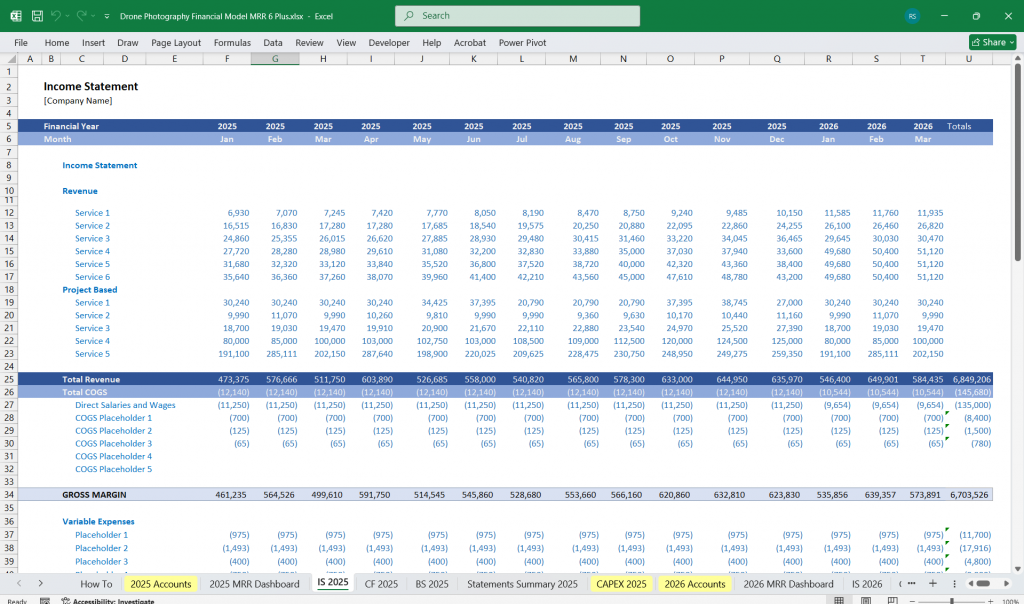
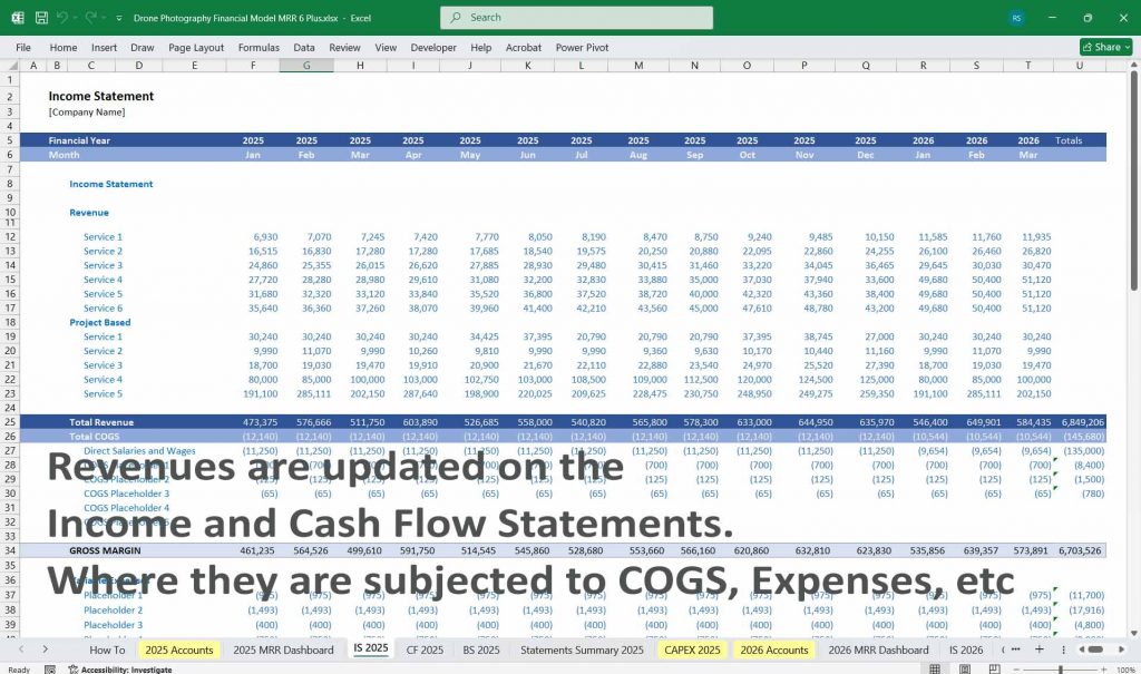
Income Statement
Revenue Streams
Subscription Monthly Recurring Revenue (MRR):
- Revenue from clients who pay a fixed monthly fee for drone photography services.
- Key Inputs:
- Monthly subscription fee.
- Number of active subscribers.
- The growth rate in subscribers.
Per Project Revenue:
- Revenue from ad-hoc projects is billed on a per-project basis.
- Key Inputs:
- Average price per project.
- Number of projects per month.
Per Hour Revenue:
- Revenue is generated by billing clients on an hourly basis.
- Key Inputs:
- Hourly rate.
- Average hours worked per project.
- Total hours billed per month.
Distance-Based Pricing Revenue:
- Revenue generated by billing is based on the distance covered during drone operations.
- Key Inputs:
- Price per distance unit (e.g., per mile or kilometre).
- Average distance per project.
- A number of distance-based projects.
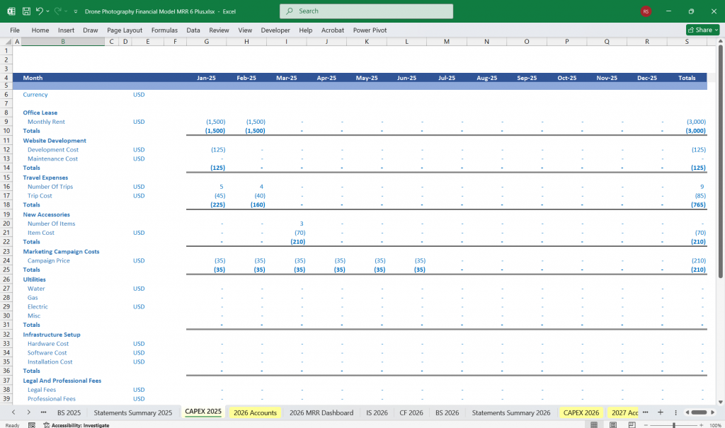
Cost of Goods Sold (COGS):
- Costs directly associated with providing the service.
- Components:
- Drone equipment maintenance and repairs.
- Consumables (e.g., batteries, propellers).
- Pilot labor costs (for hours worked).
- Fuel or electricity costs for charging drones.
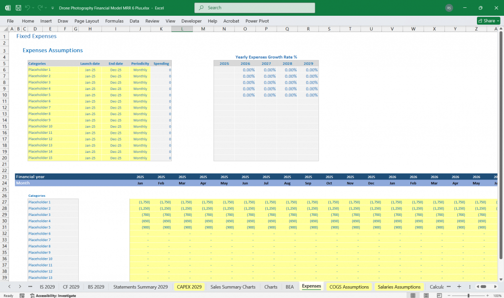
Operating Expenses:
- Fixed and variable costs not directly tied to project execution.
- Categories:
- Marketing and customer acquisition costs.
- Subscription software and cloud storage.
- Salaries (administrative staff, sales team).
- Insurance (equipment and liability).
- Rent (office or storage space).
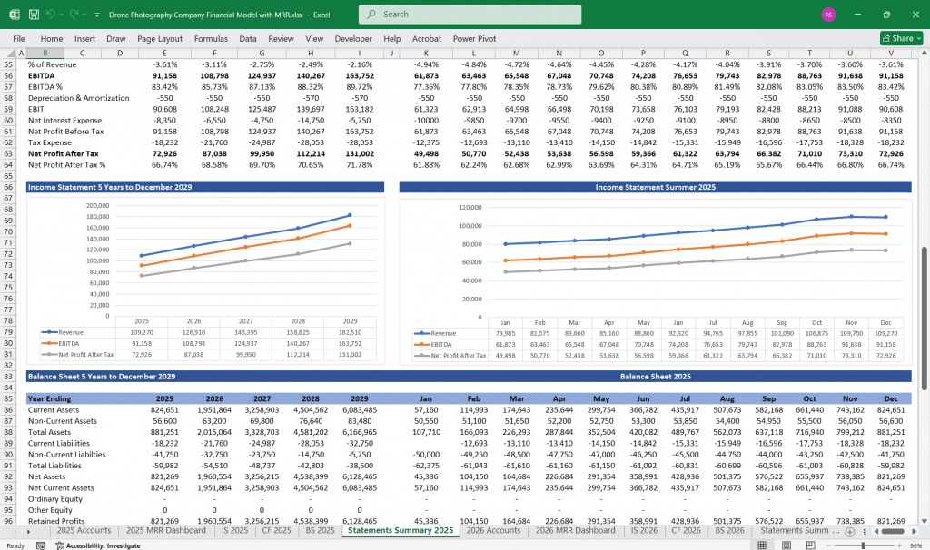
Profitability Metrics:
- Gross Profit = Revenue – COGS.
- Operating Profit = Gross Profit – Operating Expenses.
- Net Profit = Operating Profit – Taxes & Interest.
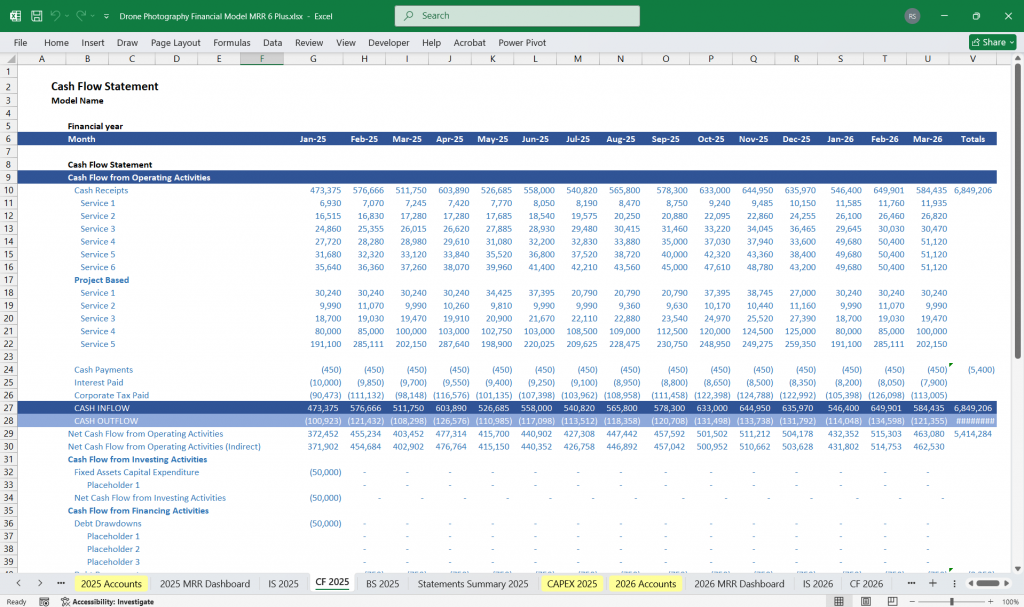
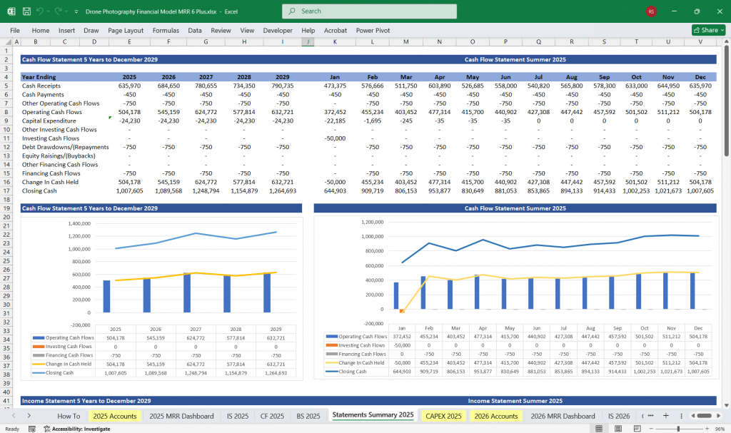
Aerial Drone Photography Cash Flow Statement
Cash Inflows:
- Customer payments from all revenue streams.
- Loans or external financing (if applicable).
- Sale of unused or obsolete drone equipment.
Cash Outflows:
- Operational Expenses:
- Salaries and wages.
- Marketing.
- Software and tools.
- Capital Expenditures (CapEx):
- Purchase of drones and accessories.
- Loan Repayments:
- Principal and interest payments on debt.
- Taxes:
- Corporate taxes are based on net profit.
- Miscellaneous Costs:
- Unexpected repairs or equipment losses.
Net Cash Flow:
- Net Cash Flow = Total Inflows – Total Outflows.
Key Metrics:
- Free Cash Flow (FCF) = Net Cash Flow – CapEx.
- Cash Flow Coverage Ratio = Cash Flow from Operations / Debt Payments.
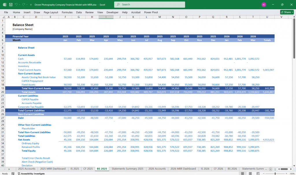
Aerial Drone Photography Balance Sheet
Assets:
Current Assets:
- Cash and cash equivalents.
- Accounts receivable (outstanding invoices from clients).
- Prepaid expenses (e.g., software subscriptions).
Non-Current Assets:
- Drone fleet (valued at purchase price minus accumulated depreciation).
- Other equipment (cameras, storage cases, etc.).
- Office space (if owned).
Liabilities:
Current Liabilities:
- Accounts payable (unpaid vendor invoices).
- Short-term loans or credit lines.
- Unearned revenue (payments received for future services).
Non-Current Liabilities:
- Long-term loans or equipment financing.
- Lease obligations (if any).
Equity:
- Owner’s equity (initial investment + retained earnings).
- Retained earnings (accumulated net profits reinvested into the business).
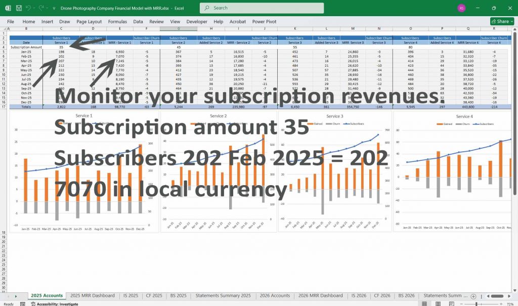
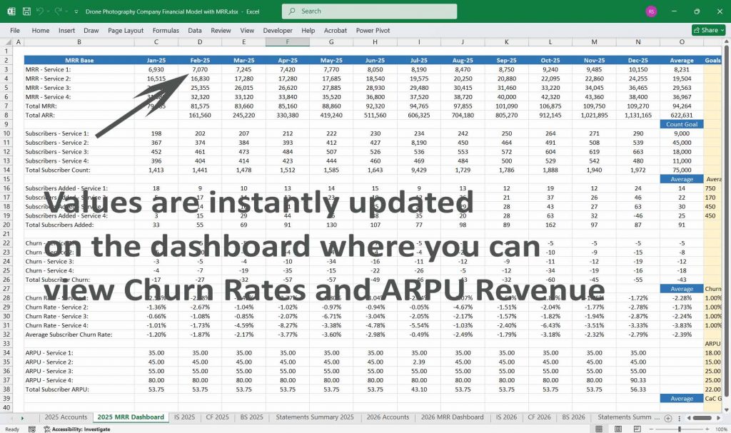
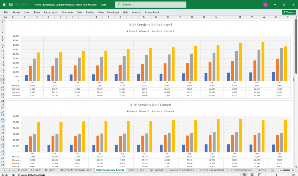
Subscription Revenue Tracking For Aerial Drone Photography Business
Focuses on tracking the recurring revenue that forms the backbone of a subscription-based business.
Monthly Recurring Revenue (MRR): Total monthly revenue generated from active subscriptions.
MRR = (Number of subscribers in each tier × Tier price).
Annual Recurring Revenue (ARR): Total expected revenue over a year from recurring subscriptions.
ARR = MRR × 12.
Metrics to Monitor
Subscriber Growth Rate:
(New Subscribers – Cancellations) / Starting Subscribers.
Churn Rate:
(Number of Cancellations / Starting Subscribers).
Lifetime Value (LTV):
Average Revenue Per User (ARPU) × Average Subscriber Lifetime.
Customer Acquisition Cost (CAC):
Total Sales & Marketing Costs / Number of New Subscribers.
LTV/CAC Ratio:
Indicates the ROI on customer acquisition.
Dashboard Components
MRR by Tier:
Breakdown of MRR across different subscription plans (e.g., Basic, Standard, Premium).
MRR Growth:
Month-over-month MRR change percentage.
Churn Analysis:
Identify patterns or reasons for subscriber cancellations.
ARR Projections:
Forecast ARR based on historical MRR trends and growth rates.
Drone Photography Per Project Pricing Model
Key Inputs:
- Average price per project.
- Average number of projects per month.
- Direct costs per project (e.g., drone usage, travel, pilot wages).
Profitability Analysis:
- Profit per project = Revenue per project – Direct costs.
Aerial Drone Photography Per Hour Pricing Model
Key Inputs:
- Hourly rate.
- Average number of billable hours per project.
- Utilization rate (percentage of available hours billed).
Aerial Drone Photography Distance-Based Pricing Model
Key Inputs:
- Price per distance unit.
- The average distance covered per project.
- Cost per distance unit (e.g., battery usage, wear and tear).
Aerial Drone Landscape Photography
- Capturing mountain ranges and valleys
- Showcasing coastlines and beaches
- Highlighting forests and wildlife with aerial drone photography
- Documenting seasonal changes
- Creating panoramic nature shots
Aerial Drone Photography Urban Exploration
- City skyline at sunrise and sunset
- Capturing busy intersections and traffic flow with aerial drone photography
- Showcasing architectural patterns
- Documenting construction projects
- Highlighting rooftop gardens and terraces
Aerial Drone Photography Real Estate Marketing
- Providing aerial property views
- Showcasing neighborhood surroundings
- Highlighting landscaping and amenities with aerial drone photography
- Creating virtual tour footage
- Documenting construction progress
Aerial Drone Photography Event Coverage
- Capturing large crowds and stages with aerial drone photography
- Filming parades and festivals
- Documenting weddings and ceremonies
- Recording sports events
- Showcasing fireworks displays
Aerial Drone Photography Travel and Tourism
- Highlighting popular landmarks
- Capturing unique cultural sites
- Showcasing natural attractions
- Filming tourist activities
- Creating travel promotional content
Aerial Drone Wildlife Photography
- Observing animal migrations with aerial drone photography
- Documenting marine life from above
- Capturing birds in flight
- Monitoring endangered species
- Minimizing disturbance with silent flight modes
Aerial Drone Photography Agricultural Monitoring
- Surveying crop health with drone photography
- Tracking irrigation patterns with drone photography
- Monitoring livestock movement via drone photography
- Assessing soil conditions
- Mapping farmland boundaries
Aerial Drone Photography Environmental Conservation
- Documenting deforestation with drone photography
- Tracking glacier movements via drone photography
- Monitoring ocean pollution
- Capturing footage of protected areas
- Raising awareness with impactful visuals
Aerial Drone Photography Search and Rescue Operations
- Surveying disaster zones
- Locating missing persons
- Delivering emergency supplies
- Guiding rescue teams
- Using infrared cameras for night searches
Aerial Drone Sports and Adventure Photography
- Capturing extreme sports like skydiving with drone photography
- Documenting rock climbing routes with drone photography
- Following surfers and waves
- Tracking mountain biking trails
- Recording racing events with drone photography
Aerial Drone Photography And Cinematic Storytelling
- Establishing shots for films
- Capturing chase scenes
- Showcasing dramatic landscapes
- Creating seamless transitions
- Enhancing visual drone photography
- narratives
Aerial Photography Drone Infrastructure Inspection
- Drone Photography surveying bridges and tunnels
- Inspecting power lines with drone photography
- Monitoring pipelines
- Checking wind turbines
- Assessing structural integrity
Aerial Drone Photography Mapping and Surveying
- Creating topographic maps
- Conducting 3D terrain modeling
- Surveying construction sites with
- drone photography
- Documenting archaeological digs with
- drone photography
- Mapping remote areas
Aerial Drone Marketing and Advertising
- Capturing product launch events
- Showcasing branded content with
- drone photography
- Filming commercials with drone photography
- Creating dynamic social media content
- Highlighting company headquarters
Aerial Drone Photography Weather Monitoring
- Drone photography and tracking storm development
- Capturing lightning and cloud formations via drone photography
- Monitoring snowfall and ice buildup
- Surveying flood zones
- Documenting climate changes over time
Aerial Drone Cultural Heritage Documentation
- Surveying historic landmarks via Drone photography
- Documenting restoration projects via Drone photography
- Mapping ancient ruins
- Capturing aerial perspectives of monuments
- Preserving digital records for future generations
Aerial Drone Photography Law Enforcement and Security
- Monitoring public gatherings with Drone photography
- Drone photography and assisting in traffic control
- Surveying crime scenes via Drone photography
- Enhancing border surveillance via Drone photography
- Supporting tactical operations
Aerial Drone Photography Educational Content Creation
- Producing geography lessons
- Documenting scientific research with Drone photography
- Creating virtual field trips
- Showcasing natural phenomena
- Enhancing classroom engagement
Aerial Drone Personal Projects and Hobbies
- Capturing family gatherings
- Documenting personal adventures
- Showcasing car or boat collections with Drone photography
- Filming DIY projects
- Practicing piloting skills
Aerial Drone Photography Future Innovations
- Experimenting with Drone photography with autonomous flight
- Integrating AI for object tracking
- Drone Developing swarm drone photography
- Enhancing real-time data Drone photography transmission
- Expanding applications in virtual reality
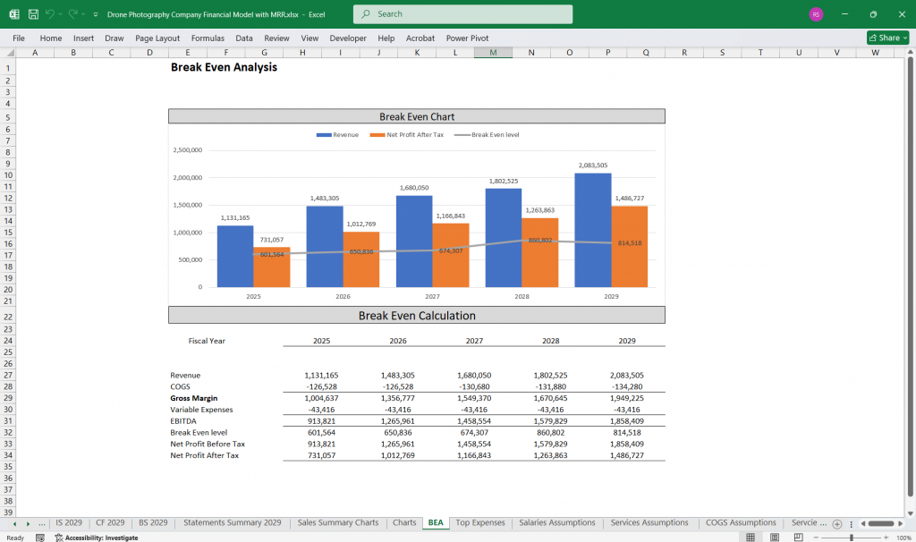
Scenario Analysis For The Financial Model
Scenarios:
- Best Case: Rapid growth in MRR, increased project bookings, and efficient cost management.
- Base Case: Moderate growth with stable costs.
- Worst Case: High churn, lower bookings, and increased operational expenses.
Key Sensitivities:
- Impact of pricing adjustments on customer acquisition.
- Sensitivity of profits to changes in COGS or operational expenses.
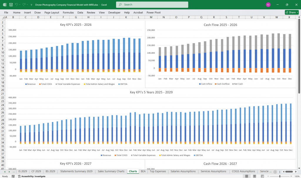
KPIs and Dashboards
Key Performance Indicators:
- Customer Lifetime Value (CLV).
- Customer Acquisition Cost (CAC).
- Gross Margin and Net Profit Margin.
- Equipment Utilization Rate.
- Return on Investment (ROI) for marketing campaigns.
Dashboards:
- Visual representations of revenue, costs, profits, and key metrics.
- Trend analysis for subscriber growth, project volumes, and revenue streams.
Download Link On Next Page